| 
The
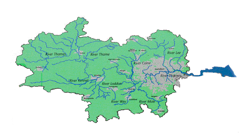
river basin is conventionally divided into four areas:
the tidal, lower, middle and upper Thames. The Upper
Thames flows from Thames Head (its source) to its confluence
with the River Windrush at Newbridge, falling 46 metres
over a distance of 64.7 km [4]. The Middle Thames runs
through the first major cities along the river —
Oxford (population 120,000), and into Reading [5]. The
first major discharge of effluent directly to the Thames
occurs in this stretch of the river — below Oxford.
The
lower Thames runs from the confluence of the River Kennet
in Reading to Teddington weir — the official upper
tidal limit of the Thames [6]. In this stretch of the
river, the flow of the Thames is supplemented both by
springs and seepages rising from the chalk aquifer,
and from tributary flow; run-off from clay is important
near the Teddington weir. At Teddington, the freshwater
flow in winter may exceed 30,000 Ml/day; but this flow
decreases significantly in summer, and has been known
to dry up completely (e.g. during the 1975/76 drought)
[7]. Under normal conditions, the Teddington flow is
maintained at a minimum of 800 Ml/day, but this may
be reduced to 200 Ml/day during times of drought. Urban
run-off, discharges from major sewage treatment works,
and tributary water of only ‘fair’ quality
all contribute to declining water quality in this stretch
of the river, as compared to the upper reaches.
The
tidal Thames, from Teddington onwards, flows through
central London, widening from less than 100m in the
upper reaches to more than 7 km at Southend. Discharge
of treated effluent from London occurs mostly downstream
of the city itself. Water quality in this final stretch
of the river is carefully monitored [7].
water
resources
Water
resources in the Thames region are supported by groundwater,
which provides a considerable base flow component to
many rivers, particularly in the upper reaches of the
catchment. The River Thames is the only major river
in the catchment; the basin is unique in England and
Wales in that the public water supply network is reliant
on one major river for water supply. The Thames functions
as a reservoir running the length of the catchment,
supplying more than half the total demand for water
through direct abstractions [1,8]. Approximately 55%
of the effective rainfall within the catchment every
year is taken up into the water supply system, more
than three quarters of which flows to the water supply
of 12 million people.
past
droughts and floods in the thames region
The
Thames region, together with the UK as a whole, has
experienced four major dry periods in the last twenty
years: 1971 to 1976 (with 5 dry years out of six), 1984
(February to August), 1988 to 1992, and 1995 to 1997
[9,10]. As water resources are groundwater-supported,
single-season meteorological droughts affect water resources
in this region less than in other regions in the UK.
Multiple season, or multi-year (‘back to back’)
meteorological droughts, such as the period from 1995
to 1997, are a more typical cause of hydrological and
agricultural droughts. The most recent groundwater drought
is the most severe since records began; many boreholes
were at or below historic minima in 1997 and the early
months of 1998.
climate
change and hydrological extreme events
The
impact of climate change on both water resources [11]
and demand patterns [12] has recently been integrated
into water management planning in England and Wales.
With the publication of the UK government’s Review
of the Potential Effects of Climate Change in the United
Kingdom in 1996 [13], the relationship between water
resources and climate change began to receive more attention.
In the same year, the economic regulator of the water
industry announced that climate change, formerly excluded
from consideration in the economic regulation process,
would now be taken into account in the next review of
water company performance.
With
regard to the possible implications of climate change,
analysis has been carried out on peak flood levels recorded
along the Thames over the past one-hundred years [14].
This show that there has been a nearly constant rate
of occurrence of flood events above a bank-full threshold,
although a greater number of extreme events occurred
in the first half of the record, i.e. before 1940. Channel
dredging and flood prevention schemes have resulted
in a localised decline in peak flood levels and event
duration.
However,
GCMs (Global Climate Models) suggest that precipitation
and runoff in the UK will increase in all areas except
south east Scotland [15]. This could indicate increased
flooding problems on major rivers like the Thames, particularly
since the precipitation increase is a winter phenomenon,
and most floods on these rivers occur in winter. The
2050 scenario indicates increased runoff of between
15-25 percent for at least two thirds of the Thames
catchment (the remainder seeing increases of between
25-100 percent). Existing flood control schemes would
be seriously underdesigned in the face of such changes;
and current insurance arrangements may no longer be
adequate - as event claims may increasingly go into
the domain of re-insurance. For example, if the changes
for the river Thames increased the flood depths for
the 100 year event by just 100 mm, the increase in damages
caused by that event (on the Windsor to Teddington reach
alone) would be from £49.3 million to £64.3
million, or an increase of over 30 percent.
The
Upper Thames flows through a predominantly rural landscape
and does not pass through any major towns. However,
the Middle Thames, from its confluence with the River
Windrush to Teddington at the head of the Thames estuary,
the runs through a predominantly urban landscape as
set out above [16]. Warning times in the upper parts
of the catchment are limited to hours, extending to
days in the lower areas, depending on the use made of
rainfall forecasts. The catchment has changed dramatically
over the last century. Crooks (1994) [14] summarises
these changes under three headings:
- Channel
dredging and clearing of all the main water courses
during the 1930s and 40s - the tributaries before
this time were in a very overgrown state. The results
of these works on the tributaries would be to increase
the rate of flood runoff into the main river.
- Increasing
urbanisation and the development of new towns - increased
runoff
- Improved
land drainage: by providing an easier path for water
to reach a main channel, flood peaks may be increased.
However, the average catchment wetness is likely to
be decreased by land drainage so that, provided that
the rate of rainfall is less than the infiltration
rate, a lower percentage of runoff will result.
The
Thames region is home to nearly 12 million people, and
is densely populated. Fourteen counties, fifty eight
district councils, and thirty three local planning authorities
in London lie wholly or partly within the region.
The
Thames region already faces pressure on its existing
water resources, with 55% of effective rainfall abstracted
for use, and a geographical mismatch between demand
(concentrated in the drier west of the basin) and supply.
The majority of demand for water is domestic, and originates
in major population centres -- such as London and surrounding
satellite cities, Banbury, Guildford, Luton, Reading,
Swindon, Oxford, and Watford. Rapidly growing urban
centres, such as Swindon in the Upper Thames, have placed
strain on local water supply in recent years.
The
Thames region is predicted to be facing significant
development pressures in the next two decades [17].
The Environment Agency has warned that: "water
resource availability is a critical factor which can
only be partially offset by reductions in leakage and
water conservation measures. Proposed levels of development
could raise serious problems for water resources in
the medium to long-term" (Environment Agency 1998,
44) [18]. In this way, Local Authorities are now required
"take water constraints into account when considering
the location of new development, including the environmental
impact of any new water resource development which may
be required as a consequence" and to "require
specific water conservation measures in new development"
(SERPLAN 1998, 40) [19].
The
limits to available water supply will be reached, if
demand continues to grow at recent rates and no new
major resource developments are initiated, within the
next 20 years [18]. The growth in single-person households
(which use more water per capita), changing consumer
goods ownership patterns, and increased garden watering
are critical factors in the growth in demand. Sustainability
reductions to meet increasingly stringent environmental
legislation (for the most part originating at the EU
level), and an increasing incidence of pollution incidents
(particularly affecting groundwater) will further reduce
water availability. As demand increases, the margin
between supply and demand (‘headroom’) will
decrease gradually. Nonetheless, as the robust performance
of water sources and lack of water restrictions demonstrated
during the most recent drought episode in the Thames
region (1995 — 1997), this increasing insecurity
of water supply will not necessarily be evident to water
consumers, unless the frequency and amplitude of extreme
meteorological drought events, in line with some climate
change scenarios, were to increase significantly.
references
1.
NRA (1994) Future Water Resources in the Thames Region:
A Strategy for Sustainable Management, Reading, National
Rivers Authority 2. NRA
(1995) Policy and Practice for the Protection of
Groundwater: Regional Appendix, Thames
Region, Reading, National Rivers Authority
3.
EA
(1998) Progress in Water Supply Planning: The Environment
Agency's Review of Water Company Water Resource Plans.
Bristol, Environment Agency
4.
NRA
(1995) Fact File: Upper Thames, Reading, National
Rivers Authority. PLACE
5.
NRA
(1995b) Fact File: Middle Thames, Reading, National
Rivers Authority. PLACE
6.
NRA
(1995c) Fact File: Lower Thames, Reading, National
Rivers Authority. PLACE
7.
NRA
(1995d) Fact File: Tidal Thames, Reading, National
Rivers Authority. PLACE
8.
Jamieson,
D. G. and N. J. Nicolson (1984) Water Resources of the
Thames Basin: Quantitative and Qualitative Aspects.
Journal of the Institution of Water Engineers and
Scientists 38 (5), 379 - 391
9.
Brown,
A. (1992) Inland water quality and pollution. The
UK Environment. A. Brown. London, HMSO: 87
- 105
10.
IOH
(1995) Hydrological Data United Kingdom: 1994 Yearbook,
Wallingford, Oxon, Institute of Hydrology and British
Geological Survey
11.
Arnell, N. W., A. Jenkins, et al. (1994) The Implications
of Climate Change for the National Rivers Authority,
NRA Research and Development Report, 12. Bristol, NRA.
12.
Herrington,
P. (1996) Climate Change and the Demand for Water,
London, Department of the Environment
13.
DoE
(1996) Review of the Potential Effects of Climate
Change in the United Kingdom. HMSO, London
14.
Crooks, S.M. (1994) Changing Flood Peak Levels on the
River Thames, Proceedings of the Institute of Civil
Engineers: Water, Maritime, and Energy 106, p. 267-279
15.
Handmer,
J.W., Penning-Rowsell, E.C, and Tapsell, S. (1998) Flooding
in a warmer world: the view from Europe. In: Downing,
et al (Eds) Climate, Change and Risk, London:
Routledge: 125-161
16.
EA (1998b) Middle Thames Fact File, Environment
Agency - Thames Region
17.
NRA
(1995e) Thames 21 - A Planning Perspective and a
Sustainable Strategy for the Thames Region, Reading,
National Rivers Authority
18.
EA (1998d) The Environment Agency's State of the
Environment Report for Thames Region, Reading,
Environment Agency - Thames Region
19.
SERPLAN (1998) A Sustainable Development Strategy
for the South East, London, The London and
South East Regional Planning Conference.
|